Introduction to the Inspiring Life of Author Mildred D. Taylor
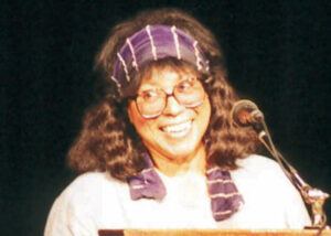
Introduction You’ve probably read a few books in your lifetime. But have you ever read a book that changed your life? That’s what Mildred D.


Introduction You’ve probably read a few books in your lifetime. But have you ever read a book that changed your life? That’s what Mildred D.

So you’re interested in becoming a podiatrist? That’s great! Podiatry is a fascinating and multifaceted field that can lead to a rewarding career. But before

If you’re not familiar with Sharon Flake, she’s a prolific author of young adult literature. Her books explore tough issues facing teenagers, from racism and

Hi, art lover! We wanted to introduce you to Shane W Evans, an extremely popular illustrator, and author. Evans was born in Columbus, Ohio, in